The information in this article applies to:

QUESTION
I would like to know how to create a plot plan in Chief Architect. How is this accomplished?
ANSWER
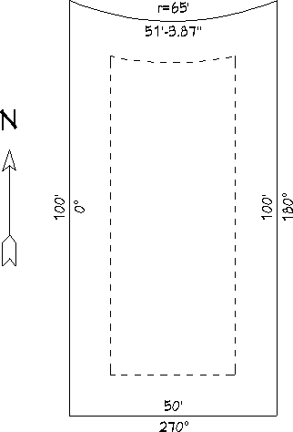
A plot plan is essentially a map of a property's legal description. This article describes how to create an accurate plot plan by inputting lines, arcs and setbacks using the CAD tools available in Chief Architect.
To create a plot plan polyline
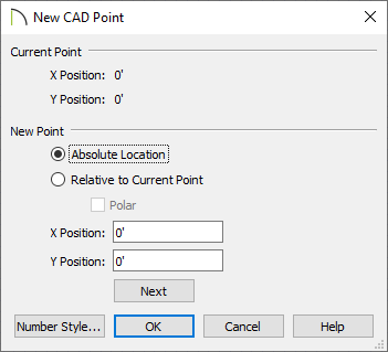
- Select CAD> Points> Input Point
 from the menu to open the New CAD Point dialog.
- Select Absolute Location, define the point's position at (0,0) for the X Position and Y Position, then click OK.
This is the current point and will serve as the Start Point for the first line of the plot plan.
- From the menu, select CAD> North Pointer
 , then click and drag the line upward to create a North Pointer pointing up to the top of the screen.
In X14 and prior select CAD> Lines> North Pointer  instead.
- Select CAD> Lines> Input Line
 to open the New CAD Line dialog. Notice that the Start Point is (0,0), which is the location of the current point that you just created. Click the Number Style button at the bottom of the dialog and in the Dialog Number/Angle Style dialog:
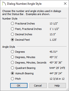
- Select Decimal Feet for the Number Style.
- Choose the Angle Style that matches your data, such as Quadrant Bearing or Azimuth Bearing.
- Click OK.
- Staying in the New CAD Line dialog, select the Relative to Start Point option and check Polar. Enter the length of the first side of your property boundary's legal description in the Distance field, and the angle of that line in the Angle field.
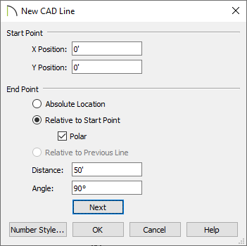
- Click Next and enter the Distance and Angle of the next property line.
The next property line will be the one adjoining the end point of your first line, rather than the start point.
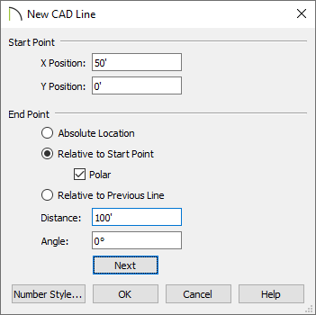
- Continue until all property lines are entered, then click OK to close the dialog.
The property line created should be closed, with the end-point of the last line being the same as the start point of the first line.
- If you'd like to remove the CAD point from the drawing go to CAD> Points> Delete Temporary Points

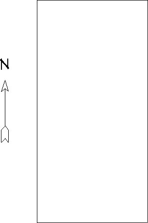
If you have received plot plan information from a surveyor, keep in mind that any given line can be described in two ways using Quadrant Bearings, and not all surveyors will describe the lines of a given plot in the same direction (ie, clockwise or counterclockwise).
If the lines are not described in the same direction, then your result will not be a closed polyline.
To correct an error
- If a line is entered incorrectly, click OK to close the New CAD Line dialog.
- Click on the incorrect line to select it, then click on the Disconnect Selected Edge
 edit button.
- With the incorrect line now separate from the rest of the polyline, it can be deleted. Select the Delete
 edit button or the Delete key on your keyboard.
- Place a CAD point at the end of the last correct line using the Place Point
 tool to create a new current point.
- Select the Input Line
 tool and continue entering data in the New CAD Line dialog as described in the section above.
To create a curved property line
- Click on an existing property line to select it, then click the Change Line/Arc
 edit button to turn this line into an arc.
- If necessary, use the triangular reshape edit handle to make the arc concave or convex.
- Click the Open Object
 edit button to open the Polyline Specification dialog.
- On the Selected Arc panel, click the Chord radio button under the Lock category, specify the length of the Radius, then click OK.
In this example, a value of 65' is specified.
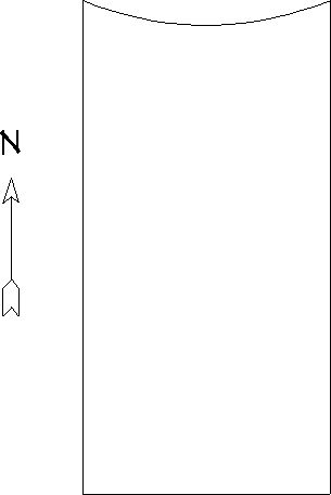
A curved property line can also be created by entering data in the New Arc dialog. See the Chief Architect Reference Manual for more information.
To display line length, angle, and arc radius information
- Select Edit> Default Settings
 from the menu, expand the CAD category, select General CAD, then click the Edit button.
- In the CAD Defaults dialog:
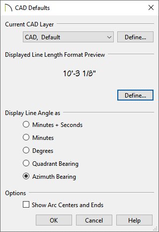
- Choose the angle display method that matches your data under the Display Line Angle as section.
- Click on the Define button under Displayed Line Length Format Preview to display the Displayed Line Length dialog, and under Accuracy, select the Decimal Places radio button
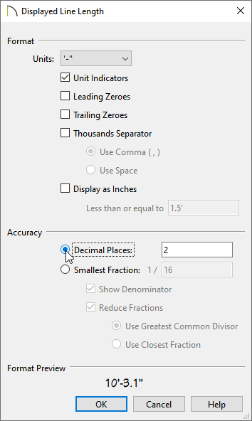
- Click OK and/or Done on all dialogs to confirm the changes.
- Click on the plot plan polyline to select it and click the Open Object
 edit button.
- On the Line Style panel of the Polyline Specification dialog:
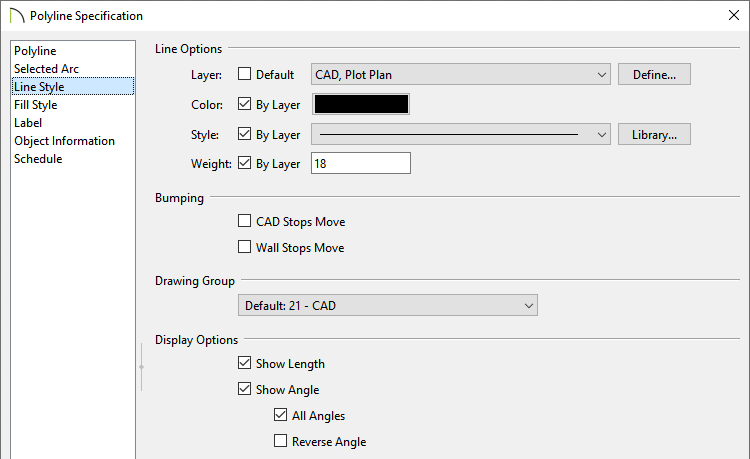
- If you're using the Plot Plan Saved Plan View, the plot plan may already be on the CAD, Plot Plan layer.
If you're not using the Plot Plan Saved Plan View, change the layer to CAD, Plot Plan, click the Define button next to the Layer drop-down, and ensure that the CAD, Plot Plan layer is set to be displayed.
For more information on layers and layer sets, please see the Related Articles section below.
- Check Show Length, Show Angle and All Angles.
- Click OK to close the dialog and apply your changes.
To create setback lines in X16 and newer
- Using the Select Objects
 tool click on your plot plan polyline to select it, click the Copy/Paste
  edit button, and then click the Paste Hold Position
  edit button.
- With the plot plan polyline selected click the Concentric Resize
 edit button.
- With the Concentric Resize
 edit button selected click the Set Concentric Jump
  edit button to open the Set Concentric Jump Distance dialog.
- In the Jump Distance box type in the setback distance required by your local planning department.
- Click OK to close the dialog and apply your changes.
- Place your cursor over a corner edit handle, then click and drag towards the center of the polyline. When a second, inner polyline displays, release the mouse.
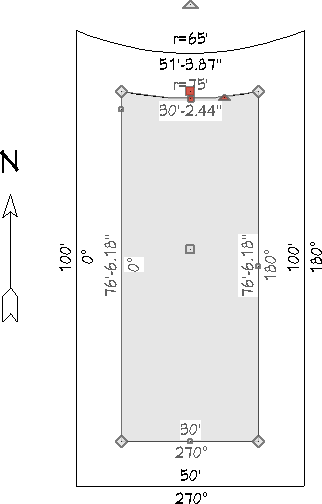
- Select the inner polyline and click the Open Object
 edit button.
- On the Line Style panel of the Polyline Specification dialog:
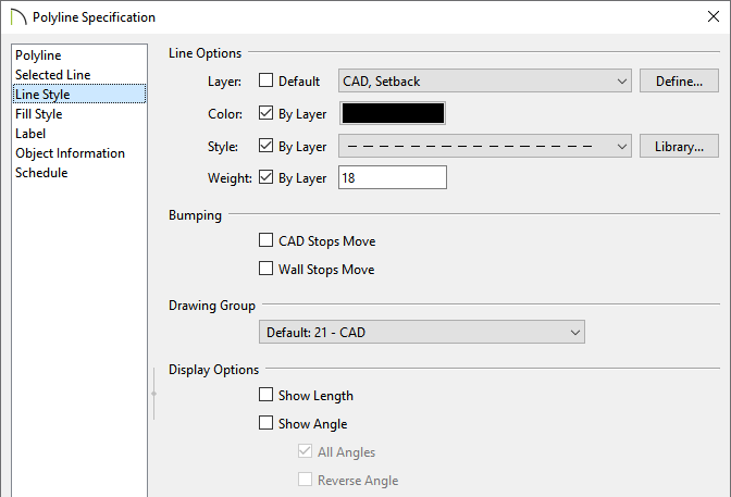
- Click the Define button next to the Layer drop-down and in the Layer Display Options dialog that displays, click the Copy button to copy the layer, and change the name of the newly created layer to CAD, Setback.
- Change the Line Style to a dashed line style.
- Uncheck the Show Length and Show Angle boxes, if desired.
- Click OK to close the dialog and apply your changes.
To create setback lines in X15 and prior
- Select Edit> Preferences
 if you're on a Windows PC or Chief Architect> Preferences
  if you're on a Mac, and on the Behaviors panel of the Preferences dialog:
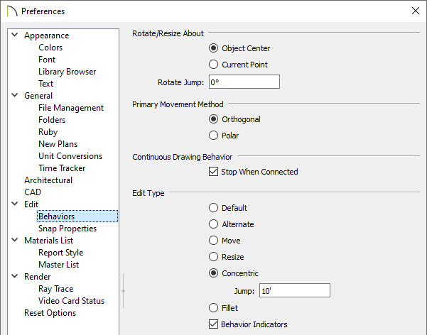
- Select the Concentric radio button under Edit Type.
- In the Jump field, type in the setback distance required by your local planning department
- Click OK to close the dialog and apply your changes.
- Click on the plot plan polyline to select it, then click the Copy/Paste
 edit button.
- Place your cursor over a corner edit handle, then click and drag towards the center of the polyline. When a second, inner polyline displays, release the mouse.

- Select the inner polyline and click the Open Object
 edit button.
- On the Line Style panel of the Polyline Specification dialog:

- Click the Define button next to the Layer drop-down and in the Layer Display Options dialog that displays, click the Copy button to copy the layer, and change the name of the newly created layer to CAD, Setback.
- Change the Line Style to a dashed line style.
- Uncheck the Show Length and Show Angle boxes, if desired.
- Click OK to close the dialog and apply your changes.
- Once the setback is created, navigate to Edit> Edit Behaviors
 and select the Default
  option to switch back to the default edit behavior.
To accurately position a building
- Navigate to CAD> Points> Place Point
 and place a point along the perimeter of the property, such as a corner. Alternately, use the starting point for your plot plan polyline, (0,0), as a reference.
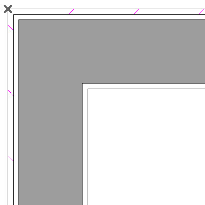
- Select CAD> Points> Input Point
 to open the New CAD Point dialog.
- Select Absolute Location and specify the desired distance that the building will be from this point in the X Position and Y Position fields.
- If you have placed a CAD point at a different location, select Relative to Current Point and specify the desired distance from that point. Unless you would like to specify the location in distance and bearing, Polar (CCW from horz) should remain unchecked.
- When you click OK, a point will be created at the specified location. Use this point as a reference to accurately position a wall or corner of the building.
To convert a plot plan to a terrain perimeter
If you'd like to have your Plot Plan appear in 3D views as a grass pad with a thickness, you can convert it to a Terrain Perimeter.
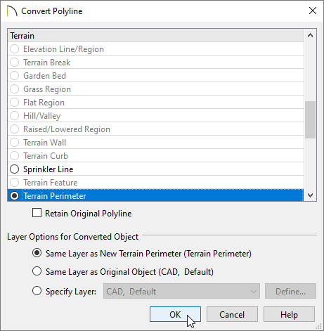
- Select the plot plan polyline and click the Convert Polyline
 edit button.
- In the Convert Polyline dialog, select Terrain Perimeter, specify the Layer you would like the Terrain Perimeter to go on, then click OK.
![]()
- Make any needed changes, then click OK to close the dialog.
The plot plan polyline that you created is now your Terrain Perimeter.

 from the menu to open the New CAD Point dialog.
 , then click and drag the line upward to create a North Pointer pointing up to the top of the screen.
 instead.
 to open the New CAD Line dialog. Notice that the Start Point is (0,0), which is the location of the current point that you just created. Click the Number Style button at the bottom of the dialog and in the Dialog Number/Angle Style dialog:


 tool to create a new current point.
 tool and continue entering data in the New CAD Line dialog as described in the section above.
 edit button to turn this line into an arc.
 edit button to open the Polyline Specification dialog.
 from the menu, expand the CAD category, select General CAD, then click the Edit button.

 edit button.

 edit button, and then click the Paste Hold Position
 edit button.

 if you're on a Windows PC or Chief Architect> Preferences
  if you're on a Mac, and on the Behaviors panel of the Preferences dialog:
 edit button.
 edit button.

 and place a point along the perimeter of the property, such as a corner. Alternately, use the starting point for your plot plan polyline, (0,0), as a reference.
 to open the New CAD Point dialog.
 edit button.